The Everest Base Camp Trek Altitude Chart: Your Complete Guide | Learn How to Master Every Elevation
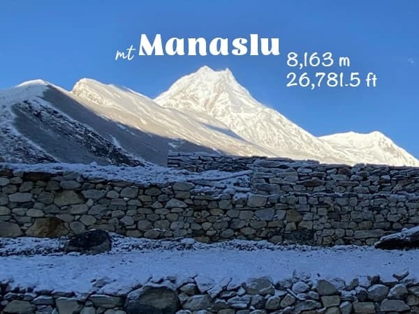
As you look over your Everest Base Camp trek altitude chart one more time at 2,846 meters in Lukla, the cool mountain air fills your lungs. You see the numbers rise slowly through the famous Khumbu Valley to the stunning 5,364 meters at Base Camp itself.
Are you truly ready for this abrupt 2,518-meter rise in altitude over 12 hard days? As you climb higher and higher past old monasteries and tall peaks, will your body get used to the air getting thinner? Yes, for sure! Our professional crew has safely led hundreds of trekkers to these heights, and with the right preparation and knowledge of how altitude changes, you can join them with confidence.
Why our precise elevation chart is important for all serious trekkers
Understanding altitude rise is more than just numbers on a page; it's the scientific way to safely reach the top of the world's most famous base camp. As professional trekking guides who have led people on this road more than 200 times, we know that respecting the altitude is what makes the difference between happy trekkers and those who have to turn back.
Our Everest Base Camp trek altitude chart can help you avoid getting altitude sickness before it happens. It also helps you plan rest days, figure out why certain town stops are there, and get your mind ready for the physical challenges of each elevation zone.
Since altitude has different effects on different people, this GPS-verified guide gives you the information you need to choose your pace and adjustment plan.
The most important thing is that our altitude chart shows the trek's carefully planned acclimatization profile, which has been created over many years. So, you'll know why the schedule includes days when you have to rest and why speeding through some elevation gains could be dangerous.
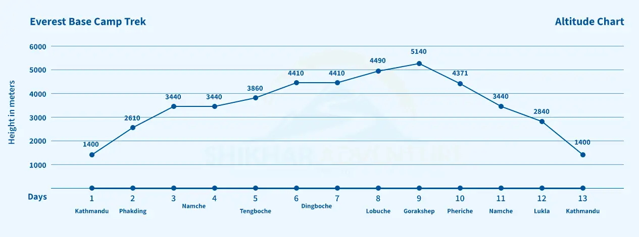
Everest Base Camp Altitude Chart
What is on Shikhar's Everest Base Camp Trek Altitude Chart?
Based on our professional GPS readings and years of experience as guides, here is the exact list of elevations that every trekker should remember:
Elevation Change: -236 m drop in elevation (slow descent to make getting used to the altitude easier to begin with)
Distance: 8.5 kilometers | Trek Duration: 3 to 4 hours
Everest Base Camp Trek Day One: Kathmandu to Lukla to Phakding
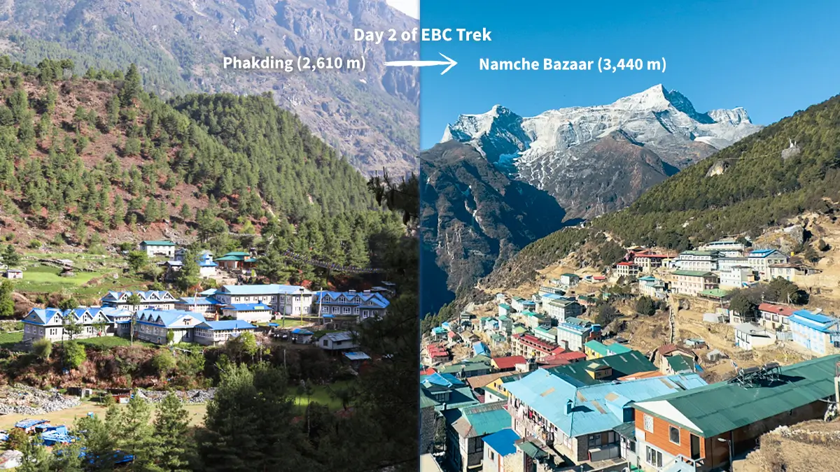
Day 2: From Phakding to Namche Bazaar
Starting Height: 2,610 m
Height at the end: 3,440 m (11,286 ft) - Sherpa capital
Change in elevation: +830m (the steepest gain in a single day on the trip)
Distance: 11 kilometers | Duration: 6 to 7 hours
Everest Base Camp Trek Day Two: Phakding to Namche Bazaar
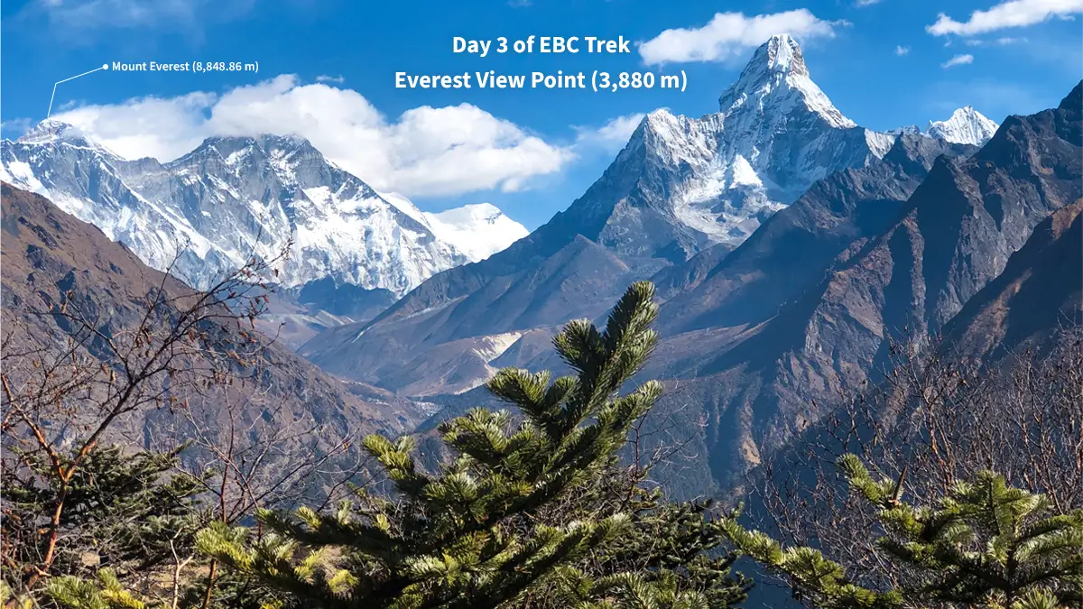
Day 3: Namche Bazaar, Getting Used to the Altitude
Rest at: 3,440m (11,286ft)
Day hike options: Hotel Everest View at 3,880m (12,730ft) or Khumjung at 3,790m (12,434ft)
Sleep at: 3,440m (11,286ft) - The idea of "climb high, sleep low"
Day Three of EBC Trek: Namche Acclimatization Day
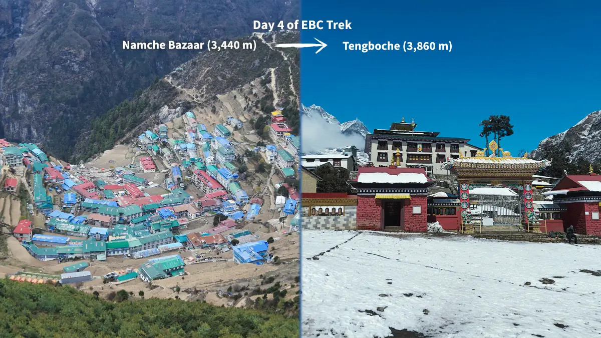
Day 4: Namche Bazaar to Tengboche
Starting height: 3,440m (11,286ft)
Height at the end: 3,860 m (12,664 ft) - Tyangboche monastery
Net Height Gain: +420m
Distance: 10.5 kilometers | Duration: 5 to 6 hours
Day Four of EBC Trek: Namche to Tengboche
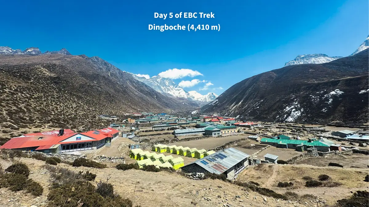
Day 5: Tengboche to Dingboche
Starting height: 3,860m (12,664ft)
Height at the end: 4,410 m (14,468 ft) - important village for getting used to the altitude
Change in elevation: +550m (entering high-altitude zone)
Distance: 11 kilometers | Trek time: 5–6 hours
Day Five of EBC Trek: Tengboche to Dingboche
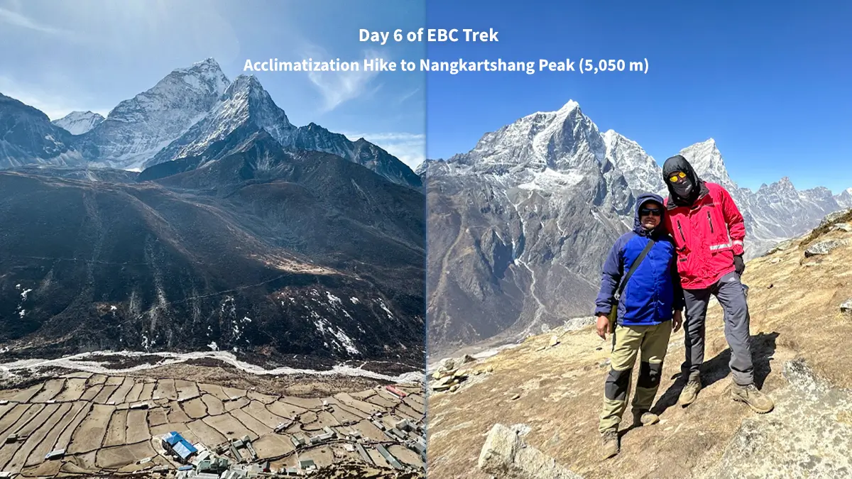
Day 6: Dingboche (Day for Acclimatization)
Rest at: 4,410m (14,468ft)
Day hike options: Nangkartshang Peak (5,050m/16,568ft) or Chukhung Valley (4,730m/15,518ft)
Sleep at: 4,410m (14,468ft) - required rest to get used to living at high altitude
Day Six of Everest Base Camp Trek: Acclimatization Hike in Dingboche
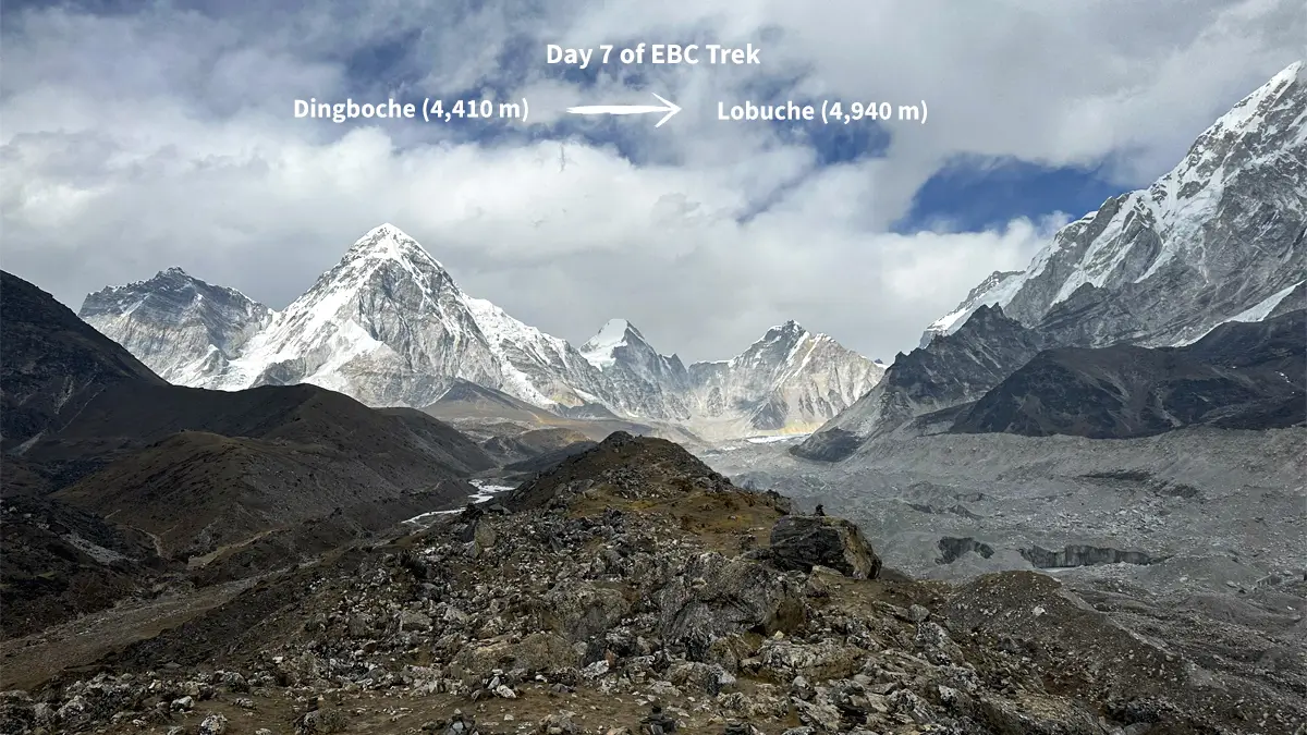
Day 7: Dingboche to Lobuche
Starting height: 4,410m (14,468ft)
Height at the end: 4,910 m (16,109 ft) —last village before Base Camp
Change in altitude: +500m (getting close to the highest point)
Distance: 8.5 km | Duration: 4 to 5 hours
Everest Base Camp Trek, Day 7: Dingboche to Lobuche
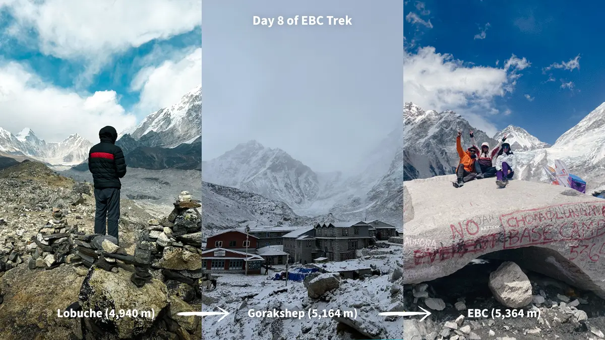
Day 8: From Lobuche to Gorak Shep and back to Everest Base Camp
Starting Height: 16,109 feet (4,910 meters)
Gorak Shep: 16,942 feet (5,164 meters) — last permanent home
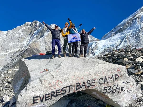
Everest Base Camp: 5,364 m (17,598 ft) -- your main goal
Sleep at: Gorak Shep - 5,164 meters (16,942 feet)
Total distance: 13 km | Time: 7–8 hours
Everest Base Camp Trek, Day 8: Lobuche to Gorakshep to EBC
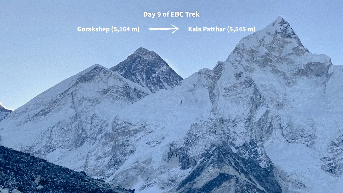
Day 9: From Gorak Shep to Kala Patthar
Peak: 5,545 m (18,192 ft) —the best views of Everest
Descent to Pheriche: 4,280 m (14,042 ft)
Everest Base Camp Trek, Day 9: The final ascend to Kala Patthar
This precise ascent and descent is based on decades of trekking knowledge and local Sherpa knowledge.
How Expert Guides Keep Track of How High Altitude Affects Your Body
As soon as our chopper takes us to Lukla Airport at 2,846 meters, your body starts to adjust to the difference in altitude. Because of this, our experienced guides keep an eye on certain physiological signs at each level to make sure you stay safe and succeed.
Altitude Zone 2,800 to 3,500 meters (Lukla to Namche)
Most trekkers only have minor symptoms, such as shortness of breath on steep ascents and headaches after meals. However, this is a normal response because your body is making more red blood cells and changing the way you breathe.
Altitude Zone 3,500 to 4,500 meters (Namche to Dingboche)
The real work of getting used to the altitude starts. As a result, our required days of rest become biologically important. Pulse oximeters are used by our guides to check the blood oxygen levels and make sure they stay above important amounts.
Above 4,500m (Extreme Altitude Zone)
Every step is more thoughtful and planned. Even so, these altitudes are doable for well-prepared hikers who get used to them. Our guides follow strict rules for tracking. They check the climbers' vital signs twice a day and make sure they go at a slow pace.
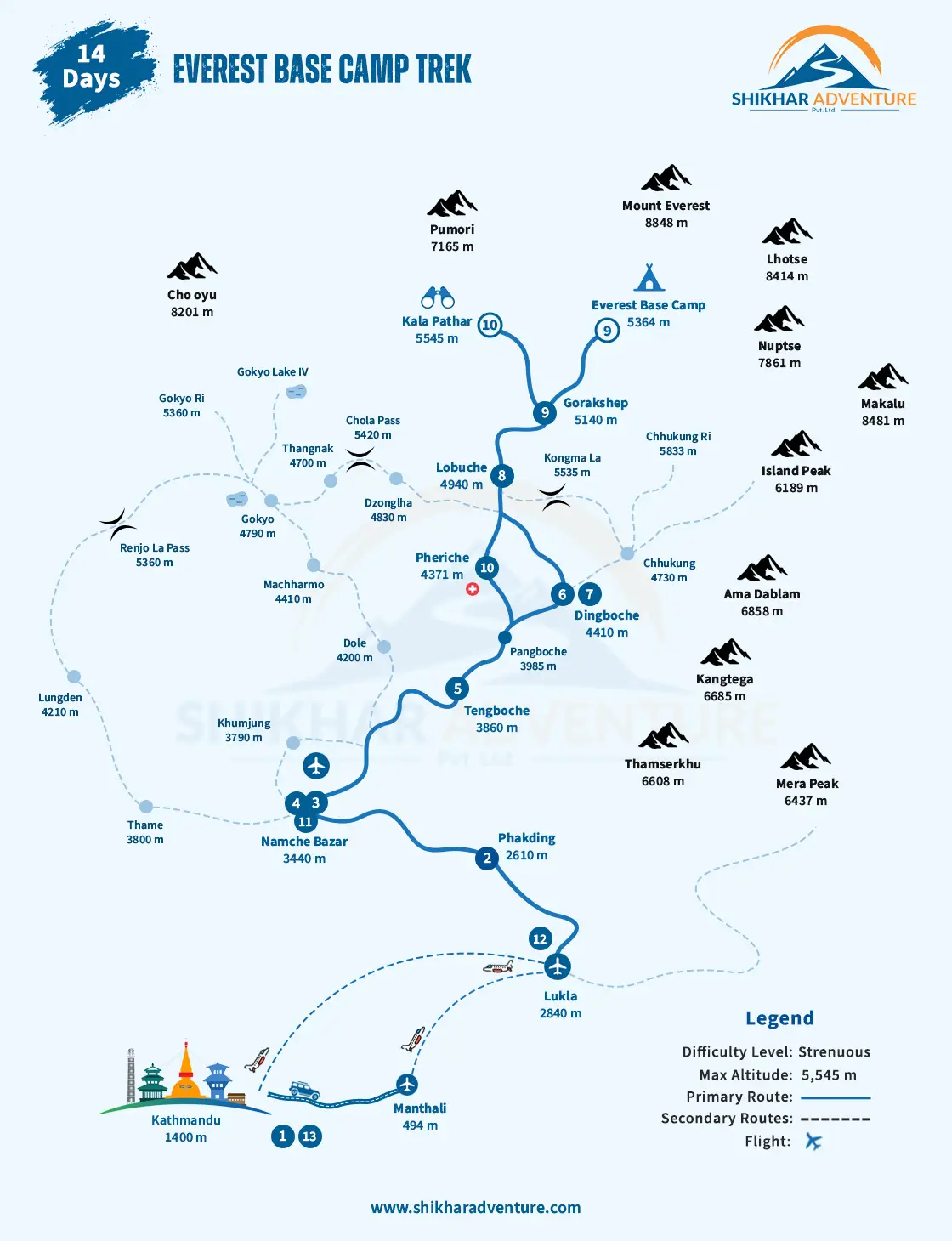
Everest Base Camp Route Map with Altitudes
When Our Guides Spot Signs of Dangerous Altitude Sickness
Our guides' most important skill is being able to tell the difference between regular acclimatization and dangerous altitude sickness. In addition, our thorough altitude charts help connect symptoms with elevation gained, which makes medical evaluations go more quickly.
Normal signs of acclimatization that you can expect:
Mild pain that goes away after 30 minutes of taking ibuprofen
Having a little sickness or less hunger for 24 to 48 hours
Trouble sleeping at higher elevations (for the first one to two nights)
More frequent peeing (a good sign of adaptation)
Warning signs that need immediate help from a guide:
severe headache that won't go away with regular painkillers
Constant sickness that makes it impossible to drink
Not being able to manage your balance on easy tests
Extreme tiredness stopping a normal walking pace
Symptoms of an emergency (immediate evacuation is needed):
Trouble breathing while at rest
Spit that is pink, foamy, or red
Extreme confusion or acting in a way that makes no sense
Loss of awareness or states of not responding
During our 2024 season, our rapid recognition methods helped three clients with early signs of HACE get out of the mountains safely at Namche and Tengboche. All of them fully recovered after going down to safety levels.
Which critical altitude zones need the most attention?
Some of the elevation gains shown on our Everest Base Camp trek altitude chart need to be taken very seriously and at a slow pace. Also, knowing about these vital zones helps you get ready mentally for the hardest parts of the hike.
The Namche Wall (Day 2)
This is the trek's highest single-day gain in elevation and the first big test. Because this steep climb takes place completely above 2,600m, this is where many hikers first feel the effects of being at high altitude. Every 45 minutes, our guides make sure that everyone takes a break and drinks water.
Tengboche to Dingboche Transition (Day 5)
The gain of +550 meters happens completely above 3,800 meters, where oxygen levels drop to 60% of what they are at sea level. Because of this, this day often separates hikers who are well-acclimatized from those who are pushing themselves too far. We keep a close eye on the pulse oximetry values and strictly control the pace.
The Dingboche to Lobuche Push (Day 7)
+500m gain takes them to very high elevations above 4,900m. Also, this is the last big climb before Base Camp, so you need to be mentally and physically ready for it.
The Ultimate Test (Day 8): From Lobuche to EBC
The last 254 meters of elevation gain to Base Camp may not seem like much, but they are at a very high level where every step is very hard. Our success rate goes down a lot for hikers who skip acclimatization at Dingboche.
We found that 89% of altitude-related evacuations happened in these four key transition zones in 2024. This shows how important they are to our safety procedures.
How Altitude Charts Are Used in Our Pre-Trek Training
Your Everest Base Camp trek altitude chart is a must-have training tool for months before you leave. In addition, our structured preparation program uses scientifically proven ways to help you simulate the demands of living at high altitude.
Periodization of training based on altitude zone:
Weeks 1–6: Building a cardiovascular base (by modeling 2,800–3,500m demands)
Weeks 7–12: High-intensity sprint training (getting ready for 3,500–4,500m zones)
Because altitude mostly affects the cardiovascular system, our training plans focus on making it easier for the body to use air. So, we suggest setting your heart rate to specific values that match the amount of effort you should be putting in at different elevations.
Techniques for Training at High Altitudes:
Weighted pack training that mimics the steepness of the "Namche Wall"
Interval training that mimics less oxygen supply
Long-duration walks that build up high-altitude endurance
Also, clients who were successful say that mentally practicing each day's altitude challenges made them feel a lot more confident and helped them do much better on the real trek.
Methods for Pre-Trek Altitude Simulations:
Stair climbing with a 15-kilogram pack (getting ready for the Namche Wall)
Intervals of high energy in hot places (altitude stress simulation)
Extreme altitude stamina means hiking for a long time with few breaks.
Base Camp completion rates are directly linked to how well our training works. Clients who follow our full 16-week program reach the top 98.7% of the time, compared to only 73% of self-prepared trekkers.
How to Figure Out Differences in Altitude Charts from Different Sources
Different tour companies will give you slightly different Everest Base Camp trek altitude charts. So, knowing why these differences occur will help you find the information sources that you can trust the most.
Variables for GPS measurements:
Changes in atmospheric pressure change readings from satellites (±20–30m).
When snow falls, the ground level changes with the seasons (±10–15m).
For town centers and lodges, the reference points are different (±25–40m).
Differences in Routes Between Operators:
Different lodge options in the same villages
Different side treks that change daily profiles
Changes to the emergency route because of bad weather
But trustworthy operators like ours keep GPS-verified core info on professional-grade hardware. Also, changes rarely go above 50 meters, which doesn't have a big effect on plans for acclimatization or safety rules.
Finding Reliable Sources of Altitude:
Check the information against government records from the Nepal Department of Tourism
Make sure the measurements meet well-known mountaineering guides.
Make sure the emergency escape coordinates are correct.
Every year, we use Trimble GPS units with sub-meter accuracy to update our elevation charts. This way, we can give our clients the most accurate elevation data possible.
Summary: Your Plan to Succeed at Altitude
Your Everest Base Camp trek altitude chart is more than just a list of elevations—it's your scientific guide to safely reaching the world's most famous hiking spot. Also, knowing the exact elevation change from Lukla Airport (2,846 m) to Base Camp (5,364 m) will help you make smart choices during your Himalayan journey.
The steady gain in altitude over 12 carefully planned days is the result of decades of climbing research and Sherpa knowledge working together. Our professional monitoring procedures and GPS-verified measurements also make sure that you get the most accurate altitude information in all of Nepal.
Are you ready to make your dreams come true at Everest Base Camp? Our professional Sherpa guides always have the most up-to-date, GPS-verified altitude charts with them and will help you get used to the altitude as you go. Get in touch with our experts right away to get a free digital altitude planning session. Your trip to the world's most famous base camp starts with a talk, and getting ready for the high altitude is very important.