The first time most trekkers see Everest clearly is not from Base Camp. It is from Kala Patthar at 5,545m, before dawn, when the summit turns orange before the rest of the range catches the light. After more than 300 trips through the Khumbu, that view still stops every group. This page covers the mountain itself: its verified height, location, names, the two main climbing routes, what it costs to attempt the summit in 2026, the death zone, and the questions trekkers and climbers ask us most before arriving
How tall is Mount Everest? The official height as of 2026
Mount Everest is 8,848.86m (29,031.7ft) above sea level. This is the official figure agreed upon by the governments of Nepal and China following a joint survey completed in December 2020. The measurement used GPS technology and snow depth radar to calculate both the rock base and the snow cap, making it the most precise survey in the mountain's history.
The previous widely used figure was 8,848m (29,028.9ft), from a 1954 Indian survey. The 2020 measurement added 0.86m and settled a long dispute about whether the snow cap should be included in the official height. Both governments agreed it should be, and the current figure reflects that.
Everest's height is not permanently fixed. The Indian tectonic plate continues pushing under the Eurasian plate at a rate of approximately 45mm per year, which means the Himalayas are still rising. Geological surveys suggest Everest gains a few millimetres annually, though this is offset in part by erosion and seismic activity. The 2015 Nepal earthquake temporarily lowered some Himalayan peaks by measurable amounts.
Everest at 8,848.86m sits on the Nepal-China border at the head of the Khumbu Valley.
Where is Mount Everest and what are its coordinates?
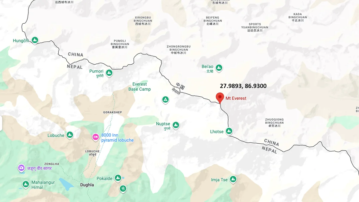
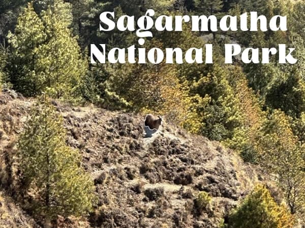
Mount Everest sits on the border between Nepal and the Tibet Autonomous Region of China, in the Mahalangur Himal sub-range of the Himalayas. Its summit coordinates are 27.9893 degrees north, 86.9300 degrees east. The mountain lies within Sagarmatha National Park on the Nepal side, a UNESCO World Heritage Site covering 1,148 square kilometres of the Khumbu region.
In Nepal, the mountain is known as Sagarmatha, meaning roughly "Peak of Heaven." In Tibetan it is Chomolungma, meaning "Goddess Mother of the World." The English name Everest was given in 1865 by the Royal Geographical Society, named after Sir George Everest, a former Surveyor General of India who led the first systematic mapping of the Indian subcontinent. He never saw the mountain himself.
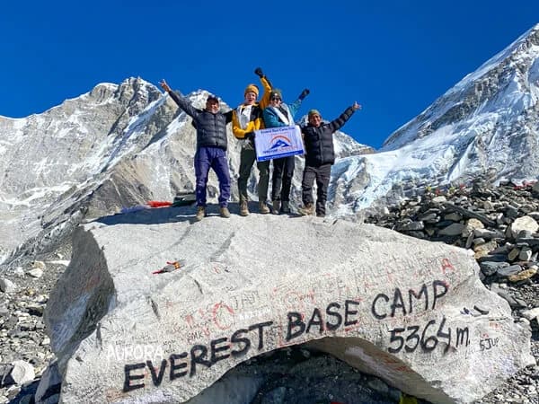
From Kathmandu, the standard approach to the Everest region is a 25-minute flight to Lukla (2,860m), followed by a 9-day trek through the Khumbu Valley to Everest Base Camp (5,364m). The Khumbu Valley passes through Namche Bazaar (3,440m), Tengboche (3,860m), Dingboche (4,410m), and Lobuche (4,940m) before reaching Gorak Shep and Base Camp.
Who first climbed Mount Everest and when?
Edmund Hillary of New Zealand and Tenzing Norgay Sherpa of Nepal reached the summit on May 29, 1953, becoming the first confirmed people to stand on top of Everest. They were part of a British expedition led by Colonel John Hunt. Tenzing Norgay was from the Solukhumbu region, the same valley that every trekker now walks through on the way to Base Camp.
Tenzing Norgay had already attempted Everest six times before the 1953 expedition. The Tenzing-Hillary Airport in Lukla is named after both of them. The Hillary School in Khumjung village, a short walk above Namche Bazaar, was established by Hillary through the Himalayan Trust and still operates today.
Whether anyone reached the summit before 1953 remains an open historical question. George Mallory and Andrew Irvine disappeared high on the Northeast Ridge in 1924. Mallory's body was found in 1999 at approximately 8,155m. Whether they summited before dying has never been definitively established.
The summit turns orange before the rest of the range catches light. Best visibility before 7am.
What are the 2 main climbing routes on Mount Everest?
Two routes are in regular use. The Southeast Ridge (South Col Route) from Nepal is the standard route and the one on which the 1953 first ascent was made. It approaches from Base Camp at 5,364m, through the Khumbu Icefall to Camp 1 at 6,065m, across the Western Cwm to Camp 2 at 6,500m, up the Lhotse Face to Camp 3 at 7,200m, across the South Col to Camp 4 at 7,906m, and from there to the summit via the Hillary Step. The majority of all Everest summit attempts use this route.
The Northeast Ridge Route from Tibet follows the north side of the mountain from the Tibetan Plateau. It was the route used by most early British expeditions, including Mallory's attempts in the 1920s. The north side is closed to foreign climbers during some political periods. It presents different technical challenges, including the notorious Second Step at approximately 8,610m, which requires fixed ladders installed by previous expeditions.
In total, 18 documented routes to the summit exist, though most are rarely attempted and require extreme technical skill. Variations of the southeast and northeast ridges account for nearly all annual summit attempts.
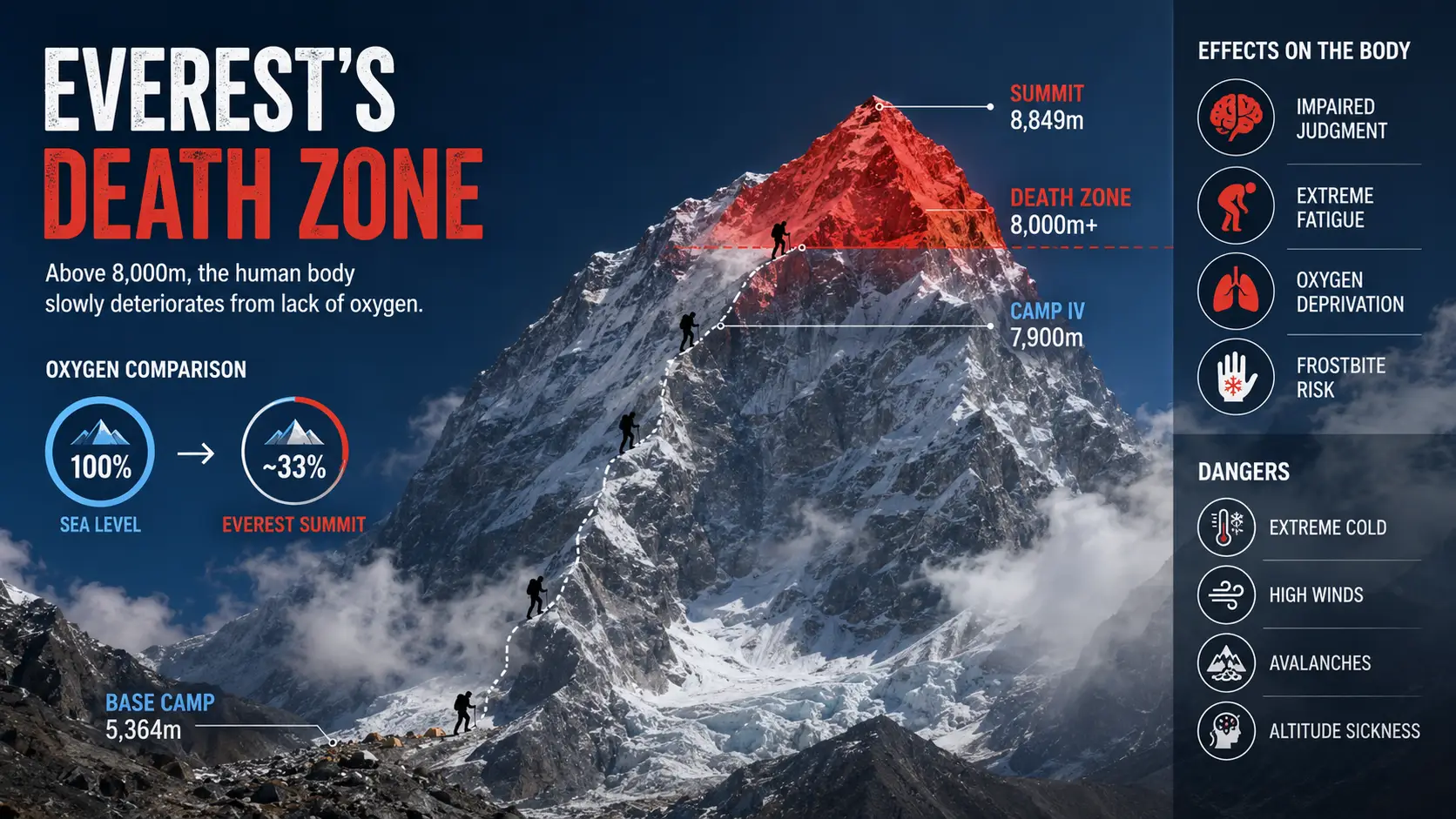
What is the death zone and how does it affect climbers above 8,000m?
The death zone refers to altitudes above 8,000m (26,247ft), where atmospheric pressure is so low that the human body cannot acclimatize regardless of time spent there. At 8,000m, the available oxygen is approximately 33 percent of sea level concentration. At the Everest summit (8,848.86m), it drops to approximately 30 percent. The body begins consuming itself to maintain function.
Without supplemental oxygen, a person at the summit is clinically in the same condition as someone breathing through a thin tube at sea level while doing heavy exercise. Most climbers cannot remain at the summit for more than a few minutes without supplemental oxygen before cognitive function degrades. Reinhold Messner completed the first oxygenless ascent in 1980, a feat considered one of the most extreme in mountaineering history.
On average, climbers use 7 oxygen cylinders across the summit push from Camp 4 to the summit and back. Each cylinder provides approximately 5 to 8 hours of supplemental oxygen at standard flow rates. Running out above 8,000m is fatal. Oxygen logistics are one of the most complex planning elements of any Everest expedition.
Above 8,000m, available oxygen drops to one third of sea level. Supplemental oxygen is standard for all commercial expeditions here.
What does it cost to climb Mount Everest in 2026?
Total expedition costs in 2026 range from approximately USD 33,590 for a basic Sherpa-led climb to USD 130,000 for a fully guided premium expedition lead guides, luxury Base Camp infrastructure, and maximum Sherpa support. Most climbers spend between USD 45,000 and USD 75,000 for a competently managed expedition.
The Nepal government climbing permit costs USD 15,000 per person for the spring season (March to May), up from USD 11,000 before September 2025. This is the largest single fixed cost and is paid to Nepal's Department of Tourism through a registered operator. The permit is valid for 55 days. Additional government fees include a liaison officer fee (approximately USD 3,000 per team) and a trash deposit (approximately USD 4,000).
Other major costs include supplemental oxygen (7 cylinders on average, USD 500 to 600 each), Sherpa climbing guide fees, Base Camp tents and meals across 6 to 9 weeks, international flights to Kathmandu, and insurance that specifically covers helicopter evacuation from above 7,000m. Standard travel insurance does not cover Everest. A policy that does costs USD 3,000 to USD 8,000 depending on coverage level and provider.
From April 2026, Nepal also requires climbers to have previously summited at least one 7,000m peak within Nepal before they are eligible for an Everest permit. This regulation, scheduled to take effect for the Spring 2026 season, is intended to reduce the number of underprepared climbers on the mountain and improve safety outcomes above Base Camp.
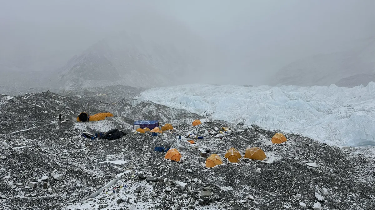
The Khumbu Glacier stretches 17km and is the world's highest glacier. Everest Base Camp sits on its right moraine at 5,364m.
What is the best time to climb or trek near Mount Everest?
The primary summit window for climbing is the second and third weeks of May. The jet stream, which generates hurricane-force winds above 8,000m for most of the year, shifts briefly north of the summit during this period. When it does, wind speeds at the summit drop enough for a summit push to be viable. In some years this window is a single day. In good years it extends to 10 to 14 days. The highest recorded wind speed at the Everest summit is 285 km/h.
A shorter autumn window exists in late September and early October, after the monsoon clears. It is less consistent than the spring window and sees fewer expedition teams. Winter ascents are possible and have been completed, but the combination of extended jet stream, extreme cold, and minimal daylight makes them among the most demanding undertakings in alpinism. The first winter ascent was made by a Polish team on February 17, 1980.
For trekkers visiting Everest Base Camp without climbing, the best seasons are spring (March to May) and autumn (September to November). Spring offers the chance to see expedition teams preparing on the Khumbu Icefall above Base Camp. Autumn has the clearest skies and sharpest mountain views. Monsoon season (June to August) brings persistent cloud and trail conditions that make trekking significantly less pleasant, though it is possible.
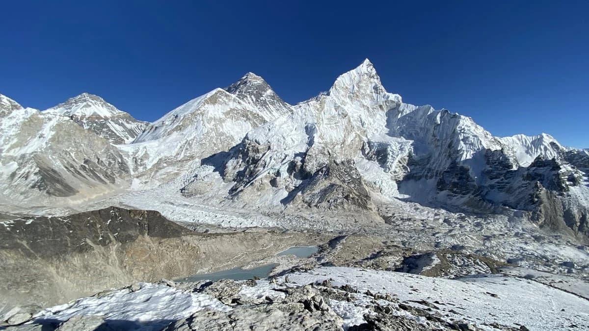
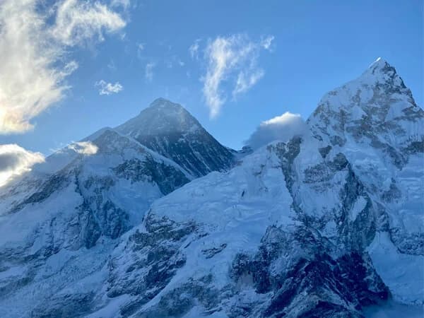
From Kala Patthar at 5,545m: Everest, Lhotse (8,516m), Nuptse (7,861m), and the Khumbu Glacier below.
How many people have summited and how many have died on Mount Everest?
As of 2025, more than 7,269 individuals have successfully reached the Everest summit, with total summit ascents exceeding 11,300 since the 1953 first ascent, as some climbers have summited multiple times. Kami Rita Sherpa holds the record with 29 summits. Apa Sherpa and Phurba Tashi each summited 21 times.
As of mid-2025, approximately 340 people have died on Everest. Over 200 bodies remain on the mountain because the conditions that make recovery operationally dangerous, and costs are estimated at USD 40,000 to USD 80,000 per body. The overall death rate has declined over recent decades as weather forecasting, fixed rope systems, and guiding standards have improved, but the mountain remains genuinely dangerous above the death zone regardless of conditions or preparation.
The deadliest single event in Everest history was the 2014 avalanche on the Khumbu Icefall that killed 16 Sherpa guides in a single morning. The 2015 Nepal earthquake triggered a separate avalanche that killed 22 people at Base Camp. Both events led to significant changes in how expedition operators structure their seasons and manage Icefall exposure for support teams.
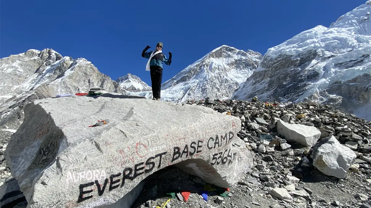
Can you see Mount Everest from Everest Base Camp?
No. The Everest summit is not visible from Everest Base Camp on the Nepal side. The West Ridge and the Khumbu Icefall above Base Camp block the line of sight. What you see from Base Camp is the lower flanks of the mountain, the Khumbu Icefall above, and the surrounding peaks including Nuptse (7,861m) and Changtse (7,583m).
The best accessible viewpoint for the Everest summit is Kala Patthar at 5,545m, a 2 to 3 hour climb above Gorak Shep. Shikhar Adventure builds a pre-dawn ascent to Kala Patthar into every EBC itinerary on the morning after reaching Base Camp, specifically for the summit view at sunrise. The summit turns orange before the surrounding range catches the light, which is the moment most trekkers photograph.
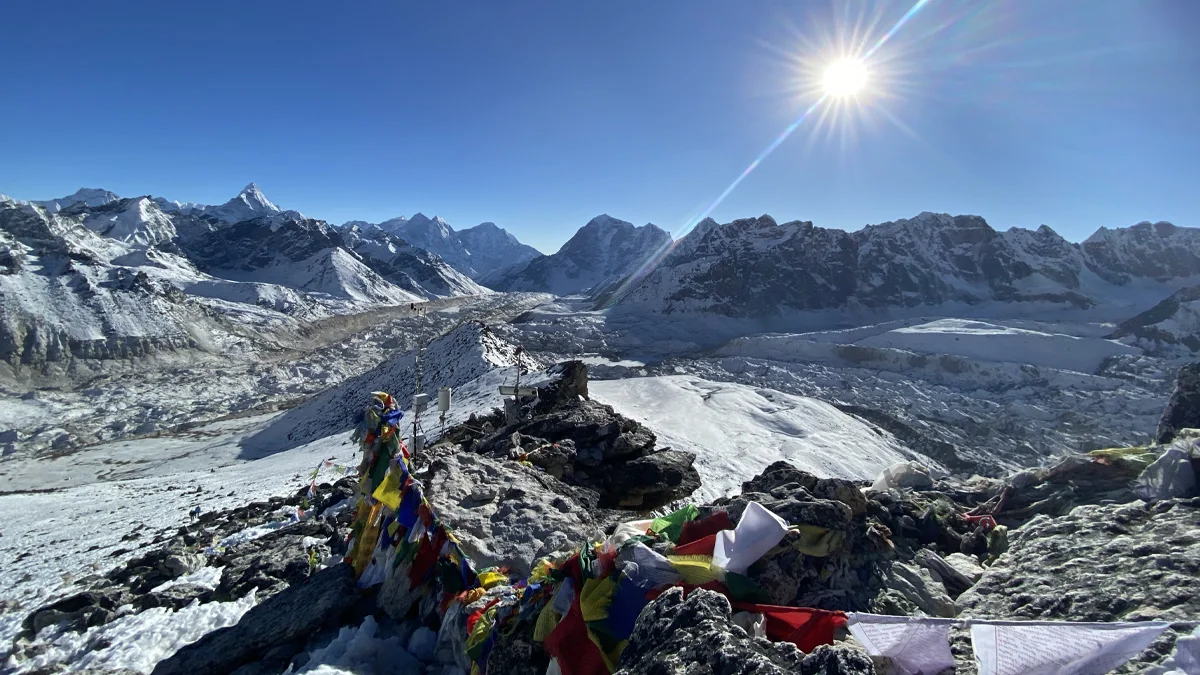
Views of Everest are also visible from Gokyo Ri (5,357m), Renjo La Pass (5,340m), and from the ridge above Namche Bazaar on a clear morning, where Everest, Lhotse, and Ama Dablam appear above the valley rim.
Treks that bring you closest to Mount Everest
Everest Base Camp Trek (14 Days) — Reaches Base Camp at 5,364m and Kala Patthar at 5,545m. The standard route for trekkers. No technical experience required.
Three Passes Trek (18 Days) — The most complete Khumbu circuit, crossing Kongma La (5,535m), Cho La (5,420m), and Renjo La (5,340m). Includes Base Camp and Gokyo.
Everest Base Camp Trek from Jiri (21 Days) — The original approach route used by Hillary's 1953 expedition. Additional acclimatization and cultural depth compared to the Lukla start.
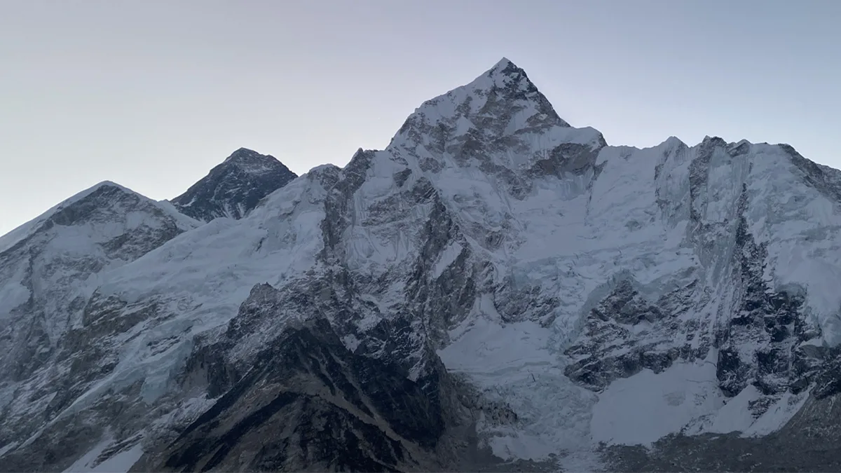
Everest Base Camp at 5,364m. The summit is not visible from here — the Khumbu Icefall above blocks the line of sight.
Common questions about Mount Everest
How tall is Mount Everest?
Mount Everest is 8,848.86m (29,031.7ft) above sea level. This is the official measurement agreed by Nepal and China in December 2020 using GPS and snow depth radar. It is the most precise measurement in the mountain's history and remains the accepted height as of 2026.
Where is Mount Everest located?
Everest sits on the border between Nepal and the Tibet Autonomous Region of China, at coordinates 27.9881 degrees north and 86.9250 degrees east. It is within Sagarmatha National Park in Nepal's Solukhumbu District, Koshi Province. The nearest road access from Kathmandu is via a flight to Lukla (2,860m) and a 9-day trek through the Khumbu Valley.
Who first climbed Mount Everest?
Edmund Hillary (New Zealand) and Tenzing Norgay Sherpa (Nepal) made the first confirmed summit on May 29, 1953. They were part of a British expedition led by Colonel John Hunt. Tenzing Norgay was from the Solukhumbu region of Nepal, the same valley trekkers walk through today on the EBC route.
What is the death zone on Everest?
The death zone is any altitude above 8,000m (26,247ft), where oxygen levels are too low for the human body to sustain itself regardless of acclimatization. At the Everest summit, available oxygen is approximately 30 percent of sea level concentration. Most commercial expedition climbers use supplemental oxygen above 7,500m and carry an average of 7 cylinders for the summit push.
How much does it cost to climb Everest in 2026?
Total expedition costs range from USD 33,590 to USD 130,000 depending on operator and service level. The Nepal government climbing permit alone costs USD 15,000 for the spring season. Additional major expenses include Sherpa fees, oxygen, Base Camp infrastructure, insurance covering helicopter evacuation above 7,000m, and international flights.
How long does it take to climb Mount Everest?
A standard expedition from Base Camp to summit and return takes 6 to 9 weeks. The Nepal climbing permit is valid for 55 days. This time includes acclimatization rotations between lower and higher camps, waiting for a summit weather window, and the summit push itself from Camp 4 through the death zone. The Khumbu Valley approach from Lukla to Base Camp adds approximately 9 days.
Can you see the Everest summit from Base Camp?
No. The Everest summit is not visible from Nepal's Base Camp at 5,364m because the West Ridge and the Khumbu Icefall above block the sightline. The best accessible viewpoint is Kala Patthar at 5,545m, 2 to 3 hours above Gorak Shep, where the summit is visible at dawn in clear conditions.
How many people have died on Mount Everest?
Approximately 340 people have died on Everest as of mid-2025. Over 200 bodies remain on the mountain because recovery at extreme altitude is operationally dangerous and costs an estimated USD 40,000 to USD 80,000 per body. The death rate has declined significantly over recent decades due to improved guiding standards, weather forecasting, and fixed rope infrastructure.
What is Everest called in Nepali and Tibetan?
In Nepali, Everest is Sagarmatha, meaning "Peak of Heaven." In Tibetan it is Chomolungma, meaning "Goddess Mother of the World." The English name Everest was assigned in 1865 after Sir George Everest, a Surveyor General of India. He never visited the mountain that bears his name.
Is Mount Everest getting taller or shorter?
The Himalayas are still rising due to the ongoing collision of the Indian and Eurasian tectonic plates. Everest gains a few millimetres annually, though erosion and seismic activity partially offset this. The 2015 Nepal earthquake temporarily altered the heights of several Himalayan peaks. Regular surveying is required to maintain accurate elevation records.
What guides who have operated in the Khumbu for 25 years know about Everest
The mountain looks different depending on where you are in the valley. From Namche at 3,440m, the summit appears between Lhotse and Nuptse on a clear morning, almost modest in scale relative to what surrounds it. By the time a trekking group reaches Lobuche at 4,940m, that perception has completely reversed. The mountain dominates everything north of you and the scale of the Khumbu Icefall above Base Camp is something no photograph accurately represents.
Most trekkers ask us whether they will see Everest clearly. The honest answer is that it depends on the morning. Autumn tends to give sharper views than spring, which is more likely to have haze from dust and expedition activity. The pre-dawn Kala Patthar ascent on a clear October morning consistently produces the best summit visibility we encounter across hundreds of trips.
The other thing worth stating directly: the mountain people come to see is not actually what defines the Everest region as a trekking destination. The Khumbu Valley has its own geography, its own culture, and its own logic. Tengboche Monastery at 3,860m, the Sherpa villages, the suspension bridges over the Dudh Koshi, the yak trains above Lobuche, and the Khumbu Icefall visible above Base Camp form an experience that most trekkers describe as more complete than they expected. Everest itself is the reason people come. The valley is the reason most of them remember the trip.
Understanding Mount Everest before you trek or climb
Everest is 8,848.86m, on the Nepal-China border, first summited in 1953, with a death zone above 8,000m and a climbing permit that costs USD 15,000 in 2026. These are the facts. What they do not communicate is the scale of the Khumbu Valley that leads to it, or the 9 days of walking through one of the most densely experienced mountain landscapes on the planet before you reach Base Camp.
For the vast majority of people who visit the Everest region, the goal is not the summit. It is Base Camp, Kala Patthar, and the view that comes from standing at 5,545m and seeing the highest point on Earth in clear morning light. That is an achievable target for a fit and well-prepared trekker with no technical experience, guided by a team that knows the acclimatization schedule and the terrain.
We have taken more than 300 groups through this valley. The trekkers who arrive with realistic expectations about the altitude, the pace, and the two acclimatization days built into the schedule are the ones who reach Kala Patthar. The mountain does not negotiate. What you can control is your preparation and who you walk with.