Manaslu Circuit Trek Difficulty
The Manaslu Circuit Trek is graded moderate to strenuous. It's not a beginner walk, but it's also not something reserved for elite mountaineers. What makes it hard isn't any single obstacle. It's the combination of consecutive long days, a steady climb to over 5,000 metres, and the remoteness of the route itself.
The toughest stretch by far is the pass-crossing day, from Dharamsala over Larkya La to Bhimthang. You're walking for 9 to 10 hours at altitude, starting in the dark and finishing on a long, knee-testing descent. Most of the days before that are manageable at a steady pace, usually 4 to 7 hours of walking on trails that climb and dip but rarely feel technical.
Being a strong hiker helps, but honestly, mindset and pacing matter more. We've guided plenty of first-timers through this trek successfully, and we've also seen very fit trekkers struggle when they rushed the acclimatisation days. Go slow, listen to your guide, and you'll be fine.
| |
Manaslu Circuit |
Everest Base Camp |
Annapurna Base Camp |
| Overall grade |
Moderate to Strenuous |
Moderate to Strenuous |
Moderate |
| Hardest single day |
Larkya La crossing (9–10 hrs) |
Kala Patthar sunrise climb |
Final push to base camp |
| Highest altitude |
5,106 m (16,752 ft) |
5,364 m (17,598 ft) |
4,130 m (13,550 ft) |
| Remoteness |
High, restricted area |
Moderate, well-trafficked |
Low, busy trail |
Altitude & Acclimatisation
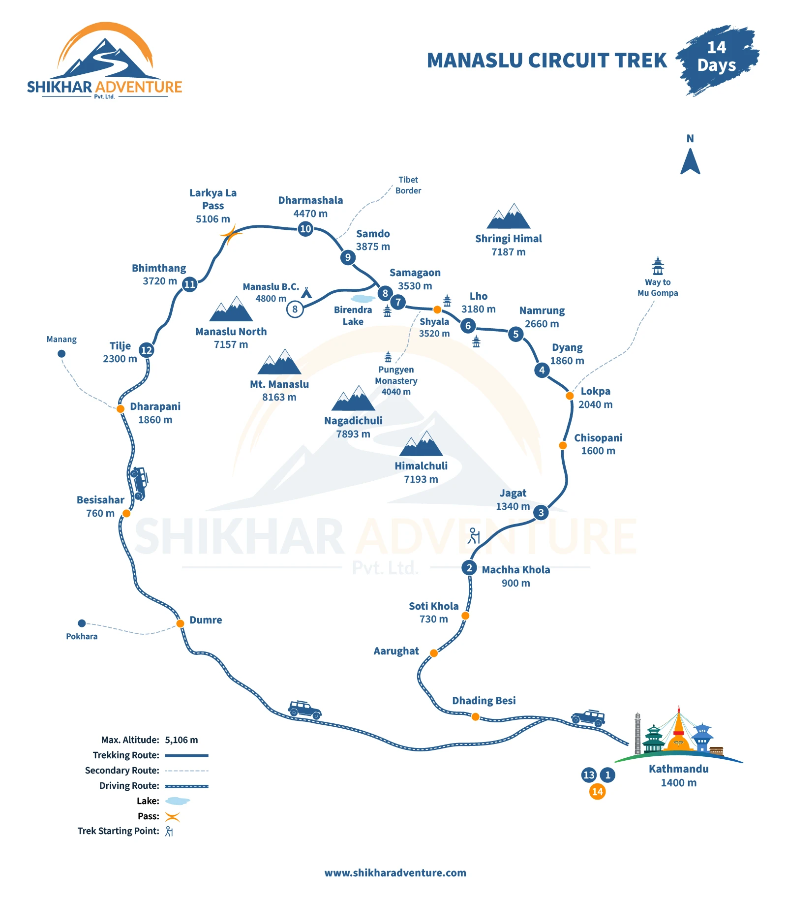
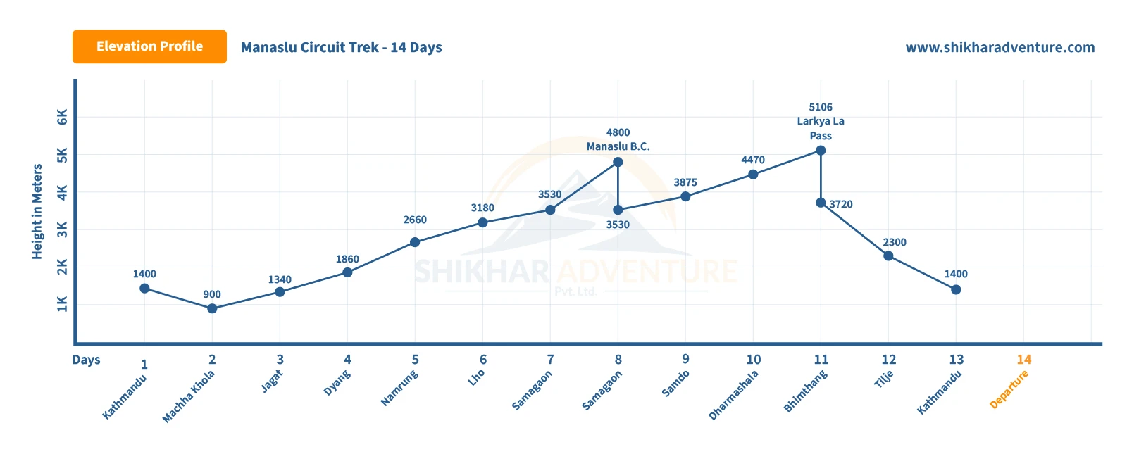
Altitude is the real challenge on this trek, more than distance or terrain. The trail climbs from 900 metres (2,953 ft) at Machha Khola to 5,106 metres (16,752 ft) at Larkya La, and your body needs time to adjust to that change in oxygen along the way.
The itinerary is built with this in mind. You spend two nights in Samagaun at 3,530 metres (11,581 ft), with a full acclimatisation day that includes a hike up toward Manaslu Base Camp. This "climb high, sleep low" approach is one of the most effective ways to reduce the risk of altitude sickness, and it's non-negotiable in our itinerary. It's also worth noting that a slower, extended itinerary with an extra acclimatisation day is available if you'd prefer more buffer before the pass.
Our guides check in on how you're feeling every day once you're above 3,000 metres. Symptoms like headache, nausea, or unusual fatigue aren't something to push through quietly. Tell your guide as soon as you notice them. Caught early, mild altitude sickness is manageable. Ignored, it can force a difficult decision about whether to continue. For a closer look at how this works and how to prepare, our altitude sickness guide for the Annapurna and Manaslu treks goes into more detail than we have room for here.
Trek Distance
From Machha Khola to Tilje, you'll cover approximately 141 km (87.5 miles) of trekking, plus another 12 km (7.5 miles) on the round-trip acclimatisation hike toward Manaslu Base Camp. That puts your total walking distance for the trip at somewhere around 150 km (93 miles).
Worth knowing: distance figures for this trek vary a fair bit between operators, depending on exactly which villages are used as start and end points and how detours are counted. Treat any total distance you see, including ours, as a close estimate rather than an exact GPS measurement.
Daily Walking Hours
Most days on this trek run between 4 and 7 hours of walking, at a pace that allows plenty of stops for photos, snacks, and simply catching your breath. A few days break that pattern in either direction.
| Day type |
Typical hours |
Example |
| Shortest days |
3–4 hrs |
Samagaun to Samdo, Samdo to Dharamsala |
| Standard days |
5–7 hrs |
Machha Khola to Jagat, Jagat to Dyang |
| Longest day |
9–10 hrs |
Dharamsala to Bhimthang via Larkya La |
Notice how the itinerary deliberately shortens the walking hours right before the pass. That's not an accident. It's there to save your energy for the day that actually needs it.
Food & Accommodation
You'll be staying in teahouses for the entire trek, and Kathmandu hotels on the nights before and after. Teahouses along the lower part of the route, up to around Namrung, tend to be fairly comfortable, with private rooms and simple attached bathrooms in many places. Higher up, especially in Samagaun and particularly at Dharamsala, expect things to get more basic. Rooms are smaller, walls are thinner, and shared bathrooms become the norm.
Meals are mostly Nepali staples: dal bhat, noodle soups, potatoes, and simple pasta dishes. Dal bhat in particular is worth embracing rather than avoiding. It's usually an all-you-can-eat plate, and it gives you the steady carbohydrate energy you need for the long days ahead. Vegetarian options are widely available, and we can accommodate most dietary restrictions if you let us know in advance.
Hot showers, Wi-Fi, and device charging are available at most teahouses for a small extra charge, though these become less reliable the higher you go. Don't expect much at Dharamsala. It's there to get you through one night before the pass, not to offer comfort.
Transportation
Getting to and from the trailhead involves two road journeys that bookend the walking itself.
| Route |
Mode |
Duration |
Upgrade option |
| Kathmandu to Machha Khola |
Local tourist bus |
8–9 hrs |
Private jeep, extra cost |
| Tilje to Besisahar |
Shared jeep |
3–4 hrs |
Private vehicle, extra cost |
| Besisahar to Kathmandu |
Hiace or tourist bus |
5–6 hrs |
Private car, extra cost |
The road between Kathmandu and Machha Khola can be rough in places, especially after monsoon rain, and delays of a few hours aren't unusual. We'd suggest building a buffer day or two into your overall Nepal trip, particularly around your return flight, so a delayed drive doesn't turn into a missed flight home.
Permits for the Manaslu Circuit Trek
You'll need three permits to trek the Manaslu Circuit, and because the region is restricted, all of them are processed through a registered agency like ours rather than picked up on your own. Here's what each one covers and what it costs.
| Permit |
Season |
Cost |
Who needs it |
| Manaslu Restricted Area Permit (RAP) |
Sept–Nov (peak) |
USD 100 for the first 7 days, plus USD 15 per extra day |
All foreign trekkers beyond Jagat |
| Manaslu Restricted Area Permit (RAP) |
Dec–Aug (off-peak) |
USD 75 for the first 7 days, plus USD 10 per extra day |
All foreign trekkers beyond Jagat |
| Manaslu Conservation Area Permit (MCAP) |
Year-round |
NPR 3,000 (approx. USD 22) |
All trekkers, entering the conservation area |
| Annapurna Conservation Area Permit (ACAP) |
Year-round |
NPR 3,000 (approx. USD 22) |
All trekkers, once you cross toward Dharapani/Tilje |
| Local Rural Municipality Entry Fee |
Year-round |
NPR 1,000 (approx. USD 8) |
Introduced in 2024, all trekkers |
Our standard 14-day itinerary spends around 7 days inside the restricted zone, from Jagat through to Tilje. On top of that, MCAP, ACAP, and the local entry fee add up to around USD 50–55 combined. All of this is already built into your trip cost with us, so you won't need to handle any of it yourself beyond providing your passport details.
One thing worth clearing up directly: TIMS (Trekkers' Information Management System) cards are not required for the Manaslu Circuit. If you see an agency listing TIMS as a separate cost, that's either outdated information or padding on their end.
Can You Trek Manaslu Solo?
As of 22 March 2026, yes. Nepal's Department of Immigration removed the long-standing rule that required a minimum of two foreign trekkers to apply for a Manaslu Restricted Area Permit together. Before this change, a solo traveller either had to find a second person to join them or pay for an extra "placeholder" permit just to satisfy the rule. That requirement is gone now, and you can apply for the RAP as a single traveller at the same per-person rate.
What hasn't changed is the guide requirement. You still need a licensed guide from a registered trekking agency to trek in the Manaslu region, solo or otherwise. This isn't a formality, it's checked at the permit counters in Jagat and again further along the trail. So "solo" here means trekking without a group of other travellers, not trekking without support. You'll still have your own guide with you throughout, and porters if you'd like one. If you're weighing up whether to go solo or join a group, we cover the practical side of this decision further down this page, and our team is happy to talk it through with you directly.
Restricted Area Regulations
Because Manaslu sits close to the Tibetan border, the government keeps a closer watch on who enters the region than it does on more open trails like Annapurna or Everest. A few things follow from that:
- You must be trekking with a licensed guide at all times inside the restricted area.
- Your permits are checked at official checkpoints, most notably at Jagat, so keep your passport and permit documents accessible, not buried at the bottom of your pack.
- Permits are issued for specific dates. If your trek runs longer than planned, whether from weather delays or a change of pace, your agency needs to handle the extension, not you.
- Travel insurance covering high-altitude trekking and emergency evacuation is expected, and may be checked alongside your permit at entry points.
None of this is designed to make the trek harder. It exists to keep the region's culture and environment intact, and to make sure that if something does go wrong at 4,000-plus metres, there's a clear paper trail showing who's out there and with whom.
Add-On to Tsum Valley
If two weeks in the Manaslu region isn't quite enough, the Tsum Valley is worth considering as an extension. It branches off the main trail near Lokpa, leading into a side valley that's arguably even less visited than the Manaslu Circuit itself, with monasteries like Mu Gompa and Rachen Gompa and a strong, still-living Tibetan Buddhist tradition.
Combining the two adds roughly 5 to 7 days to your trip and requires an additional Tsum Valley permit alongside your Manaslu permits. If this interests you, mention it when you enquire and we'll build it into a custom itinerary. You can also see our dedicated Manaslu & Tsum Valley Trek or standalone Tsum Valley Trek packages for a sense of how this extension is usually structured.
Best Seasons for the Manaslu Circuit Trek
The best time to trek the Manaslu Circuit is spring (March to May) or autumn (September to November). Both seasons offer stable weather, clear mountain views, and a safe window for crossing Larkya La. Outside of these months, the trek gets noticeably harder and, at times, genuinely risky.
| Season |
Conditions |
Pros |
Cons |
Spring
(Mar to May) |
Mild, mostly clear, rhododendrons in bloom |
Comfortable temperatures, colourful lower trails, good pass conditions later in the season |
Early March can still have leftover snow on Larkya La; occasional afternoon haze |
Autumn
(Sept to Nov) |
Dry, crisp air, the clearest mountain views of the year |
Most reliable weather window, best visibility, ideal pass conditions |
Busiest of the two good seasons; nights turn cold quickly by late November |
Winter
(Dec to Feb) |
Very cold, heavy snow possible at altitude |
Near-empty trail, dramatic snow-covered scenery |
Larkya La can become genuinely dangerous or impassable; some teahouses above Samagaun close |
Monsoon
(Jun to Aug) |
Wet, humid at lower altitudes, higher landslide risk |
Lush green valleys |
Muddy trails, poor visibility, higher risk of road delays and landslides in the lower gorge |
If you're deciding between spring and autumn, autumn generally has the edge for reliability. Spring wins if you want to see the rhododendrons in bloom and don't mind slightly less predictable skies.
Weather by Season
Temperature on this trek depends far more on altitude than on the calendar. A warm spring afternoon in Machha Khola and a night in Dharamsala can feel like two different planets.
| Zone |
Spring / Autumn Daytime |
Spring / Autumn Night |
| Lower valley (Machha Khola to Jagat, under 1,500 m) |
15°C to 25°C (59°F to 77°F) |
5°C to 12°C (41°F to 54°F) |
| Mid-hills (Namrung to Lho, 2,500–3,200 m) |
10°C to 18°C (50°F to 64°F) |
0°C to 8°C (32°F to 46°F) |
| High villages (Samagaun, Samdo, 3,500–3,900 m) |
5°C to 12°C (41°F to 54°F) |
-8°C to -2°C (18°F to 28°F) |
| Dharamsala & Larkya La (4,460–5,106 m) |
-2°C to 10°C (28°F to 50°F) |
-15°C to -8°C (5°F to 18°F) |
Note that these are typical seasonal ranges, not a forecast. Wind chill near Larkya La can make it feel considerably colder than the numbers suggest, especially at your 4 am start. In winter, expect all of these figures to drop further, sometimes well below -15°C (5°F) at the pass.
Fitness Requirements
You don't need to be a mountaineer for this trek, but you do need a genuine baseline of fitness. If you can comfortably hike 5 to 7 hours on hilly terrain with a daypack, on consecutive days, you're in reasonable shape for Manaslu.
Here's a simple way to think about preparing, starting roughly 8 to 12 weeks out:
- Cardio base: 3 to 4 sessions a week of running, cycling, or brisk hiking, building up gradually in duration.
- Load-bearing hikes: Practice hiking with a daypack of 5 to 8 kg on varied terrain, including stairs or hills, at least once a week.
- Consecutive-day training: Try back-to-back hiking days at least once before you go, so your body knows what recovering overnight and walking again the next morning actually feels like.
- Final month: Taper the intensity but keep the frequency, and focus on rest and sleep quality as your trip gets closer.
Age isn't the deciding factor here. We've guided trekkers well into their sixties and seventies who prepared properly and did just fine, and we've seen younger, very fit trekkers rush the acclimatisation days and pay for it later. Preparation and pacing matter more than raw athleticism.
Packing Guide
Packing well for Manaslu means preparing for two climates in one trip: warm, humid lower valleys and genuinely cold high-altitude nights. Here's what we recommend, grouped by category.
Clothing
- Lightweight, broken-in trekking boots
- Moisture-wicking trekking socks, several pairs
- Quick-dry thermal base layers, top and bottom
- An insulating mid-layer, such as a fleece or down jacket
- A wind and waterproof outer shell jacket
- Lightweight, breathable hiking pants (convertible styles work well)
- Shorts, for the warmer lower-altitude days
- A warm knit hat for high altitude, plus a sun hat or cap for lower down
- Insulated, waterproof gloves
- A buff or scarf, useful for both warmth and sun protection
Gear
- A sleeping bag rated to at least -15°C, given the cold at Dharamsala and above
- Trekking poles, especially valuable on the Larkya La descent
- A comfortable daypack for daily essentials
- A water bottle or bladder (2-litre minimum), plus a purification method
- A headlamp with spare batteries, essential for the pre-dawn pass crossing
- Gaiters, useful if you encounter snow near the pass
Personal Items
- High-SPF sunscreen, the sun is stronger than it looks at altitude
- SPF lip balm, to prevent painful wind- and sun-cracked lips
- A basic first-aid kit, including any personal medications
- Toothbrush, toothpaste, and biodegradable soap
- Wet wipes and a quick-dry travel towel
Extras
- A camera, though your phone will do most of the work these days
- Energy bars, nuts, or dried fruit for the long walking days
- Travel insurance documents covering high-altitude trekking and evacuation
- Cash in Nepali rupees for snacks, charging fees, and small purchases along the way
If you're missing something on this list, don't worry too much before you arrive. Kathmandu has plenty of gear shops in Thamel where you can rent or buy anything you're short on, and our team is always happy to point you in the right direction.
Cost of the Manaslu Circuit Trek
The Manaslu Circuit Trek with Shikhar Adventure costs from US$1,095 to US$1,325 per person, depending on your group size. There's no vague "price on request" here, and no separate quote for solo travellers. If you're trekking alone, you'll see exactly what that costs before you book.
| Group Size |
Price per Person |
| 1 person (solo) |
US$1,325 |
| 2–4 people |
US$1,195 |
| 5–8 people |
US$1,095 |
The reason solo travellers pay a bit more per person is straightforward: your guide's wage, permits, and vehicle costs get spread across fewer people. It's the same underlying trek and the same quality of guiding, just a different way the fixed costs divide up. With the 2026 permit change now allowing solo applications, we wanted a clear, honest solo rate rather than turning independent travellers away or quoting them privately at inflated prices.
This price covers permits, a licensed guide, accommodation and meals during the trek, and transport between Kathmandu and the trailhead. It doesn't cover your international flights, personal spending, or a few specific extras, which we've broken down clearly below so there are no surprises once you're on the trail.
Optional Add-Ons
A few ways to tailor the trip further, if you'd like:
- Private vehicle upgrade for the Kathmandu–Machha Khola and return legs, instead of the local bus
- An extra acclimatisation day built into the schedule, useful if you'd rather have more buffer before Larkya La
- Tsum Valley extension, adding roughly 5 to 7 days for a deeper cultural detour (see the Tsum Valley section above)
- Additional nights in Kathmandu, either before or after the trek, if you'd like more time to rest or explore
Let us know what you're interested in when you enquire, and we'll adjust your quote accordingly.
Safety on the Manaslu Circuit Trek
Is the Manaslu Circuit Trek safe? Yes, for the vast majority of trekkers who prepare properly and trek with a licensed guide, which is mandatory here in any case. The main risks aren't exotic. They're altitude, weather, and remoteness, and all three are manageable with the right approach.
Our guides carry a basic first aid kit and are trained to recognise the early signs of altitude sickness before they become serious. We build acclimatisation days into the itinerary rather than treating them as optional, and your guide will check in on how you're feeling once you're above 3,000 metres. If symptoms don't improve, or worsen, descending is always the right call, and it's one your guide is trained and empowered to make.
Rescue in this region means either walking down to a lower altitude or, in a genuine emergency, helicopter evacuation. This is exactly why travel insurance that covers high-altitude trekking and emergency evacuation isn't optional, it's a real safeguard in a genuinely remote part of the world. We go into this in more depth in our guide to the real dangers on the Annapurna and Manaslu circuits, which is worth a read if you want the fuller picture beyond what we can cover here.
Guides & Porters
Every trek we run on Manaslu is led by a government-licensed guide with genuine, repeated experience on this specific route, not someone assigned to it for the first time. That matters more here than on busier trails, because the margin for a wrong call near Larkya La is smaller.
Porters carry your main duffel bag so you can walk with just a daypack, and we're committed to fair treatment of our crew as a matter of course, not a marketing line. That means fair wages, proper insurance, and reasonable load limits, because a trek run on the back of underpaid, overloaded porters isn't one we're willing to sell. If you'd like to know who's likely to guide your specific trip, our team page introduces the guides and staff you'll actually be working with.
Responsible Tourism, Culture, and Sustainable Travel
Manaslu's remoteness is exactly why it's worth protecting. The villages you'll walk through, Lho, Samagaun, Samdo, are still largely self-sufficient, and the Tibetan Buddhist traditions here are lived daily, not staged for visitors.
A few things go a long way toward keeping it that way. Carry out what you carry in, especially plastic. Ask before photographing people, particularly at monasteries or during religious moments. Dress modestly around religious sites, and walk clockwise around mani walls and stupas, which is the traditional direction of movement here. Buying tea, snacks, or handicrafts directly from village shops rather than only from larger lodges also puts more of your money directly into the local economy you're passing through.
We also keep group sizes manageable and work with local guesthouse owners rather than large, disconnected chains, because the trek's appeal depends on the region staying the way it is.
Wildlife
The trail runs through the Manaslu Conservation Area, home to genuinely rare species including the snow leopard and red panda. Realistically, sightings of either are uncommon. These are shy, elusive animals in a vast, rugged landscape, and most trekkers won't see one.
What you're more likely to spot are Himalayan tahr on the higher, rockier slopes, langur monkeys in the forested lower sections, and a wide range of birdlife throughout. Treat any wildlife sighting as a bonus rather than an expectation, and you won't be disappointed either way.
Photography Opportunities
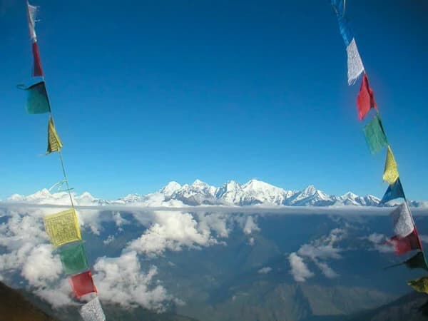
This is a genuinely photogenic trek, and a few spots are worth planning around if photography matters to you. The approach to Lho, where Manaslu first comes fully into view, is one of the best. Birendra Lake, with its glacial blue water framed by snow-capped peaks, is another. And the summit of Larkya La itself, weather permitting, offers a sweeping panorama that includes Manaslu, Himlung Himal, and Cheo Himal.
If you're chasing golden-hour light, mornings in Samagaun with Manaslu's south face catching the first sun are hard to beat. Just remember that battery life drops faster in cold, high-altitude conditions, so carry a spare if photography is a priority for you.
Internet, Charging & Practical Logistics
Internet & Charging
Wi-Fi is available at most teahouses up to around Samagaun, usually for a small fee of about US$2 to 4 per day. Beyond Samagaun, connectivity becomes patchy and, at Dharamsala, effectively non-existent. Device charging follows a similar pattern: reliable and paid for lower down, limited and more expensive higher up. A power bank is a worthwhile addition to your packing list for the final few days.
Drinking Water
Bottled water is sold along the route, but we'd encourage bringing a reusable bottle and a purification method, whether tablets, a filter, or a UV steriliser, instead. It's better for the environment in a region already managing a growing volume of plastic waste, and it works out considerably cheaper over two weeks.
Electricity
Most teahouses run on a mix of hydro and solar power, which is generally reliable at lower altitudes but can be inconsistent higher up, especially during poor weather. Bringing a headlamp with spare batteries covers you for any gaps.
ATMs & Money
There are ATMs in Kathmandu and a few in Besisahar, but nothing reliable once you're on the trail itself. Carry enough Nepali rupees in cash from Kathmandu to cover charging fees, Wi-Fi, snacks, and any extras for the full trek, since there's no way to withdraw more once you've left the road.
Mobile Network
Nepal Telecom (NTC) generally has the best coverage in this region compared to other Nepali providers, though signal is intermittent above Samagaun and effectively absent at Dharamsala and the pass itself. If you need to stay reachable, let people know in advance that you'll likely be offline for a few days around the pass crossing.
Travel Insurance
Travel insurance isn't optional for this trek, it's a requirement, and for good reason. Your policy needs to specifically cover high-altitude trekking up to at least 5,200 metres, and it needs to include emergency helicopter evacuation. Standard travel insurance policies often exclude altitude trekking above a certain height, so check the fine print rather than assuming a generic policy will cover you here.
We're not able to arrange this on your behalf, but we can point you toward providers who specialise in Himalayan trekking coverage. Our travel insurance guide covers what to look for in more detail, and it's worth reading before you buy a policy rather than after.
Solo Travellers
Since the March 2026 permit change, solo trekkers can apply for the Manaslu Restricted Area Permit individually, without needing to find a second person first. You'll still trek with your own licensed guide throughout, so you're never genuinely alone on the trail, but you won't be tied to anyone else's pace or preferences either. If independence is what draws you to this trek, this is very good news, and our solo pricing above reflects a straightforward, honest rate rather than a workaround.
Group Departures
If you'd rather trek alongside other travellers, joining a small group keeps costs down and often adds a social element to the trip. Group sizes stay manageable by design, both for the trail's sake and so your guide can genuinely look after everyone properly on the harder days.
Private Trips
Travelling with your own group of friends, family, or colleagues? A private trip gives you full control over pace, rest days, and any itinerary tweaks, without coordinating around strangers. This is a popular option for people who want the flexibility to slow down on a tough day without holding up a bigger group.
Family Suitability
This trek is achievable for older teenagers and fit, experienced younger trekkers, but it's not one we'd recommend for young children given the altitude, the remoteness, and the demands of the Larkya La crossing specifically. If you're considering it as a family, talk to us directly about ages and fitness levels first. We'd rather give you an honest answer than a sale.
Before You Book
A short checklist worth running through before you commit:
- Confirm your Nepal visa requirements. Most nationalities can get a visa on arrival at Kathmandu airport, but it's worth checking based on your passport. Our Nepal visa information guide covers this.
- Arrange travel insurance that covers high-altitude trekking and helicopter evacuation before you arrive, not after.
- Book your international flights with a buffer of a few days around your return date, in case road delays push your schedule back.
- Check with your doctor about any relevant vaccinations or medications, including whether Diamox is appropriate for you.
- Review our payment process so there are no surprises when it's time to secure your booking.
Frequently Asked Questions
What is the Manaslu Circuit Trek?
The Manaslu Circuit Trek is a 14-day trek that circles Mt. Manaslu, the world's eighth-highest mountain at 8,163 metres, crossing the Larkya La Pass at 5,106 metres (16,752 ft). It runs through Tibetan-influenced villages in a restricted area of Nepal and requires a licensed guide throughout.
How long is the Manaslu Circuit Trek?
Our standard itinerary is 14 days, including 2 days in Kathmandu at the start and end. The actual trekking portion covers about 12 days on the trail. Shorter and longer versions are possible if you'd like to customise the pace.
How difficult is the Manaslu Circuit Trek?
It's graded moderate to strenuous. Most days involve 4 to 7 hours of walking on manageable terrain, but the Larkya La crossing day is genuinely demanding, with 9 to 10 hours of walking at high altitude. Good preparation and pacing matter more than raw fitness.
Is the Manaslu Circuit Trek harder than Everest Base Camp?
They're similar in overall difficulty, but Manaslu's toughest day, the Larkya La crossing, is arguably more demanding than any single day on the EBC route, mainly due to the early start and long descent. Manaslu also involves more consecutive remote days with fewer services.
How much does the Manaslu Circuit Trek cost?
With Shikhar Adventure, it costs from US$1,095 to US$1,325 per person, depending on group size: US$1,325 for solo trekkers, US$1,195 for groups of 2 to 4, and US$1,095 for groups of 5 to 8. This includes permits, guide, accommodation, and meals during the trek.
Can I trek the Manaslu Circuit solo?
Yes. Since 22 March 2026, Nepal's Department of Immigration removed the requirement for a minimum of two trekkers to apply for the Manaslu Restricted Area Permit. You can now apply as a solo traveller, though you'll still need a licensed guide, which remains mandatory in this restricted area.
Do I need a guide for the Manaslu Circuit Trek?
Yes, a licensed guide from a registered trekking agency is mandatory, regardless of whether you're trekking solo or in a group. This is checked at permit checkpoints, including at Jagat.
What permits do I need for the Manaslu Circuit Trek?
You'll need the Manaslu Restricted Area Permit (RAP), the Manaslu Conservation Area Permit (MCAP), and the Annapurna Conservation Area Permit (ACAP), plus a local rural municipality entry fee. All of these are arranged through your trekking agency, and all are included in our trip cost.
Do I need a TIMS card for the Manaslu Circuit Trek?
No. TIMS (Trekkers' Information Management System) cards are not required for the Manaslu Circuit as of 2026. If an agency lists this as a separate cost, it's outdated or unnecessary.
What is the highest altitude on the Manaslu Circuit Trek?
The highest point is Larkya La Pass at 5,106 metres (16,752 ft). The second-highest point most trekkers reach is the optional Manaslu Base Camp side hike at 4,800 metres (15,748 ft).
How do I avoid altitude sickness on this trek?
Follow the itinerary's built-in acclimatisation days, particularly the extra night in Samagaun, walk at a steady pace rather than rushing, stay well hydrated, and tell your guide immediately if you notice headaches, nausea, or unusual fatigue above 3,000 metres.
What's the best time to trek the Manaslu Circuit?
Spring (March to May) and autumn (September to November) are both good choices, offering stable weather and safe conditions for crossing Larkya La. Autumn tends to have the most reliable visibility overall.
Can you trek the Manaslu Circuit in winter?
It's possible in early winter, but Larkya La becomes genuinely risky once heavy snow sets in, and some teahouses above Samagaun close. We don't recommend crossing the pass during peak winter months.
Can you trek the Manaslu Circuit during monsoon season?
We don't recommend it. Monsoon (June to August) brings a higher risk of landslides in the lower gorge sections, along with muddy trails and poor visibility.
How cold does it get on the Manaslu Circuit Trek?
Nighttime temperatures near Dharamsala and Larkya La can drop to -15°C (5°F) or lower, even in the best seasons. Lower villages stay far milder, often 15°C to 25°C (59°F to 77°F) during the day.
How many kilometres is the Manaslu Circuit Trek?
The trekking portion covers approximately 141 km (87.5 miles) from Machha Khola to Tilje, plus around 12 km (7.5 miles) for the round-trip acclimatisation hike toward Manaslu Base Camp. Total distance figures vary somewhat between operators depending on exact start and end points.
How many hours do you walk each day?
Most days involve 4 to 7 hours of walking. The shortest days, such as Samagaun to Samdo, take around 3 to 4 hours. The longest day, crossing Larkya La, takes 9 to 10 hours.
What kind of accommodation is available on the trek?
You'll stay in teahouses throughout, ranging from fairly comfortable lower down to quite basic near Dharamsala. Rooms are typically simple twin rooms, with shared bathrooms becoming more common at higher altitude.
What food is available during the trek?
Mostly Nepali staples: dal bhat, noodle soups, potatoes, and simple pasta dishes. Dal bhat is usually served as an all-you-can-eat plate and is a good source of steady energy. Vegetarian options are widely available.
Is there Wi-Fi on the Manaslu Circuit Trek?
Yes, at most teahouses up to around Samagaun, usually for a small daily fee. Beyond that point, connectivity becomes patchy and is essentially unavailable at Dharamsala.
Can I charge my phone and camera during the trek?
Yes, at most teahouses, for a small fee, though options become more limited the higher you go. A power bank is worth packing for the final few days before and after the pass.
Are there ATMs along the Manaslu Circuit Trek?
No, not once you leave the road network. Carry enough Nepali rupees in cash from Kathmandu to cover the whole trek, since there's no way to withdraw more on the trail.
Do I need travel insurance for this trek?
Yes, it's mandatory, and it needs to specifically cover high-altitude trekking up to at least 5,200 metres, plus emergency helicopter evacuation. Standard travel insurance often excludes this, so check carefully before buying a policy.
What happens if I get altitude sickness on the trek?
Your guide will monitor you closely above 3,000 metres and will recommend descending if symptoms don't improve. In more serious cases, helicopter evacuation is arranged, which is exactly why appropriate travel insurance is required.
Is the Manaslu Circuit Trek safe?
Yes, for well-prepared trekkers travelling with a licensed guide, which is required regardless. The main risks are altitude, weather, and the remoteness of the route, all of which are manageable with proper acclimatisation and a guide who knows the trail.
How fit do I need to be for this trek?
You should be comfortable hiking 5 to 7 hours on hilly terrain with a daypack, on consecutive days. Training for 8 to 12 weeks beforehand, combining cardio with load-bearing hikes, is a sensible approach.
Can beginners do the Manaslu Circuit Trek?
Yes, with proper preparation and a realistic understanding of the difficulty. Prior trekking experience helps, but isn't essential. What matters more is fitness, pacing, and following your guide's advice on the pass-crossing day.
What should I pack for the Manaslu Circuit Trek?
Layered clothing for both warm lower valleys and freezing high-altitude nights, a sleeping bag rated to at least -15°C, trekking poles, a headlamp, and standard trekking gear. See our full packing guide above for the complete list.
Can I rent trekking gear in Kathmandu?
Yes, Thamel has plenty of gear shops where you can rent or buy anything you're missing, from sleeping bags to down jackets.
How do I get to the start of the Manaslu Circuit Trek?
You'll drive from Kathmandu to Machha Khola, which takes about 8 to 9 hours by local bus, with a private vehicle upgrade available if you'd prefer more comfort and flexibility.
How do I get back to Kathmandu after the trek?
From Tilje, you'll take a shared jeep to Besisahar, then continue by Hiace or tourist bus to Kathmandu, a combined journey of around 9 to 10 hours.
Can I extend the trek to include Tsum Valley?
Yes. Adding the Tsum Valley extension typically adds 5 to 7 days and requires an additional permit. Mention this when you enquire and we'll build a custom itinerary for you.
What wildlife might I see on the Manaslu Circuit Trek?
The route passes through the Manaslu Conservation Area, home to snow leopards and red pandas, though sightings of either are rare. You're more likely to see Himalayan tahr, langur monkeys, and a variety of birdlife.
Is the Manaslu Circuit Trek crowded?
No, it's one of Nepal's quieter restricted-area trails. Because every trekker needs a permit and a guide, numbers stay far lower than on Everest Base Camp or the Annapurna Circuit.
How does the Manaslu Circuit compare to the Annapurna Circuit?
Manaslu is more remote and requires a restricted area permit and mandatory guide, which the Annapurna Circuit doesn't. Manaslu also tends to be quieter, with a stronger, more consistently Tibetan-influenced culture along the route.
Do I need a visa to trek in Nepal?
Most nationalities can get a visa on arrival at Kathmandu airport. Check our Nepal visa information guide for the specifics based on your passport.
What's the group size on this trek?
We keep group sizes manageable, and you can also book privately with your own group of friends or family, or trek solo with just your guide.
Is the Manaslu Circuit Trek suitable for families?
It can work for older teenagers and fit, experienced younger trekkers, but we don't recommend it for young children given the altitude and remoteness. Talk to us directly if you're considering it as a family.
What is Larkya La Pass?
Larkya La is the highest point of the trek at 5,106 metres (16,752 ft), historically a trade route between Nepal and Tibet. Crossing it is the most physically demanding single day of the trip, but also the most rewarding.
Do I need prior high-altitude trekking experience?
No, but it helps if you've done some hiking before and have a sense of how your body responds to exertion. Many first-time high-altitude trekkers complete this trek successfully with proper preparation.
What should I do if the weather delays my trek?
Build a buffer of a few days into your Nepal trip, particularly around your return flight, since road access to Machha Khola can be delayed by weather. Your guide and agency will help manage any itinerary adjustments needed.
How do I book the Manaslu Circuit Trek with Shikhar Adventure?
You can book directly through our website, or message us on WhatsApp if you'd rather talk through the details first. See our payment guide for how the booking process and deposit work.
Ready to Trek the Manaslu Circuit?
If you've read this far, you already have a realistic picture of what this trek involves: the quiet trails, the long climb to Larkya La, the culture that stays genuinely lived-in rather than performed. That's worth something, and it's exactly why people come back from Manaslu talking about it differently than they do about busier treks.
Whether you're ready to book, still deciding between solo and group, or just have a question you haven't seen answered above, we're an easy message away. Reach out on WhatsApp, send an enquiry, or go ahead and book your spot directly below.
Book This Trip | Customize Trip | Message Us on WhatsApp